by Wyland Clost and Farrah Soeharno
Indonesia contains approximately 13.4 million hectares of tropical peatland and stores around 28.1-57 gigatons of carbon, making it one of the largest tropical peat storages in the world (Lesari et al. 2023). More than half of these peatlands degraded or drained due to the illegal logging, large scale plantations, agriculture expansions, and the repeated peat fires over the years (Miettinen et al. 2016; Dohong et al. 2017 in Lestari et al. 2023). When peatlands are drained and burned, large amounts of carbon dioxide and methane are released, turning a long-term carbon sink into a major emission source causing effects like haze, health impacts, and significant economic losses. The restoration of tropical peatlands is crucial for communities as well as the climate in Indonesia, they store enormous amounts of carbon inside and offer many essential vital ecosystem services like water regulation, fisheries, and livelihoods.
Looking closely at the peatlands within Sungai Buluh in Tanjung Jabung Timur, Jambi, these landscapes emerge as one of Indonesia’s climate heavyweights: storing massive amounts of carbon, supporting high biodiversity, as well as providing many resources for the economy in the surrounding villages. Yet increasing pressures from land-use change and hydrological disturbance have begun to threaten these functions. These conditions make one thing clear: restoration is not optional, but it must be done correctly.
From Degradation to Restoration: A Governance Turning Point

- Map of the Sungai Buluh Protected Forest area (Doc. FINCAPES & I-CAN)
Pematang Rahim Village Forest is located within the Sungai Peat Protected Forest and the Buluh Peat Protected Forest, forming part of a wider peatland landscape dominated by secondary peat swamp forest. This landscape exhibits mixed conditions, with some areas remaining relatively intact while others are visibly degraded.
In response to these conditions, the Forest Management Unit of Tanjung Jabung Timur (Unit Pelaksana Teknis Daerah Kesatuan Pengelolaan Hutan Produksi, UPTD KPHP Tanjung Jabung Timur) has prioritised the implementation of social forestry. Since 2017, approximately 19 social forestry permits have been issued, covering around 20,000 hectares, enabling local communities to legally manage forest and peatland areas that were previously governed under informal or unclear arrangements. Several villages surrounding the Sungai Buluh area, including Pandan Sejahtera and Catur Rahayu, have begun piloting peatland restoration activities, such as canal blocking and rewetting, replanting, and livelihood-supporting interventions.¹
So, what does it actually take to restore peatlands properly?
Peatland restoration in Indonesia is widely understood as a combined technical and governance challenge, requiring interventions that address peat hydrology, vegetation recovery, and livelihoods within an integrated institutional framework. National-level assessments show that restoration efforts frequently fail not due to the absence of technical solutions, but because of fragmented planning, weak coordination among actors, and insufficient attention to social and tenure-related risks (Lestari et al., 2023). In response, Indonesia’s peatland restoration framework has increasingly emphasized community-based approaches and social forestry as mechanisms to reduce implementation risks while strengthening local stewardship.
At the national level, the Peatland and Mangrove Restoration Agency (Badan Restorasi Gambut dan Mangrove, BRGM) plays a central coordinating role by setting restoration priorities, facilitating rewetting, revegetation, and livelihood revitalization, and promoting collaboration among central and local governments, communities, and concession holders. Effective peatland restoration therefore depends not only on technical interventions, but also on multi-actor coordination and risk-informed governance frameworks that integrate national policy direction with locally grounded implementation.
At the local level, these national principles are translated into practice through what communities commonly describe as the “three Rs”: rewetting, revegetation, and revitalization. In practice, this involves restoring peat hydrology by raising water tables, replanting peat-adaptive species, and revitalizing local livelihoods to ensure that restoration generates tangible socio-economic benefits. As highlighted in community-based peatland restoration studies across Southeast Asia (Purnomo et al., 2023), revitalization is not a complementary activity but a core pillar of restoration, as social and economic resilience directly influence long-term ecological outcomes. Given the interconnected, sponge-like structure of peatlands, restoration interventions are most effective when planned at the scale of the Peat Hydrological Unit (Kesatuan Hidrologi Gambut/KHG), rather than as isolated site-level actions, an approach shown to reduce hydrological disruption, fire risk, and downstream degradation.
Furthermore, evidence from Indonesia and Southeast Asia consistently shows that restoration initiatives are more likely to succeed when communities play a central role throughout the full restoration cycle, from planning and implementation to monitoring and benefit-sharing. Community leadership, supported by farmer groups, women’s groups, community action arenas, local institutions, and village-level rules, strengthens social capacity, reinforces collective norms, and aligns restoration objectives with local knowledge and livelihoods. These social and institutional foundations are repeatedly identified as key enabling conditions for effective, sustained peatland restoration (Purnomo et al., 2023).
In Jambi Province, these approaches are embedded within the Governor’s Regulation on peatland management, which defines permitted and prohibited activities as well as recommended restoration practices. The Forest Management Unit (Kesatuan Pengelolaan Hutan, KPHP) plays a key operational role by translating this regulatory framework into day-to-day guidance, organizing Social Forestry Business Groups (Kelompok Usaha Perhutanan Sosial, KUPS), working with permit holders, and supporting communities to develop sustainable peatland-based livelihoods.
Building the Evidence Base: Restoration Guided by Data

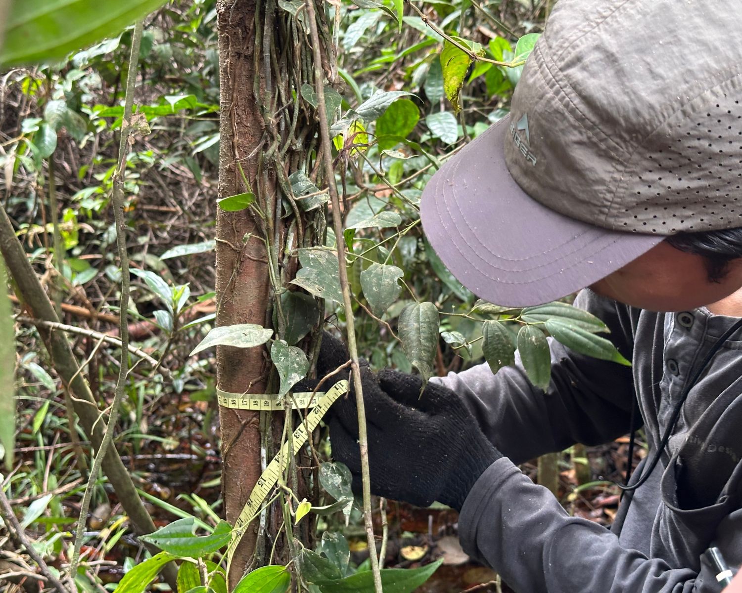
1. Taking mineral sampel of peatsoil in Sungai Buluh (Doc. I-CAN/Sophie Fathima); 2. I-CAN and FINCAPES team deep in the peat in Sungai Buluh Peat Protection Forest. (Doc. I-CAN/Sophie Fathima); 3. Soil experts from the FINCAPES team determining peat depth in Sungai Buluh Peat Protection Forest. (Doc. I-CAN/Wyland Clost); 4. IPB Peat Expert Prof. Sri Wilarso and team walking through the Peatland in Sungai Buluh Peat Protection Forest. (Doc. I-CAN/Wyland Clost)
Building on these lessons, the FINCAPES-supported IPB Center for Applied Research in Nature-based Solutions (I-CAN) is designing its peatland restoration work in Pematang Rahim to explicitly address both biophysical and socio-institutional dimensions of restoration. Through its Living Laboratory approach, I-CAN is generating baseline evidence on vegetation, peat and soil characteristics, hydrology, carbon stocks, biodiversity, and greenhouse gas emissions, while simultaneously documenting socio-economic conditions related to livelihoods, land tenure, gender roles, and decision-making.
By integrating ecological data with social and governance insights, the Living Lab is intended to support applied research, collaborative learning, and locally grounded innovation, ensuring that peatland restoration interventions are technically sound, socially inclusive, and responsive to community realities.
To generate the required biophysical data, the research team establishes permanent and semi-permanent plots to map vegetation structure, record tree species composition and density, and assess forest condition. Field measurements include peat depth, groundwater levels, and soil characteristics, alongside greenhouse gas sampling using closed chamber methods to quantify carbon dioxide (CO₂) and methane (CH₄) fluxes. These measurements provide baseline and trend data on peat hydrology, carbon dynamics, and ecosystem recovery.
Complementing this, the social research component employs household surveys and semi-structured interviews to document livelihood strategies, land tenure and control arrangements, and gendered decision-making processes within households and communities. This mixed-methods approach situates local findings within broader national patterns.
At the national scale, Lestari et al. (2023) estimate that approximately 6 million hectares, around 45% of Indonesia’s peatlands, are classified as “potentially restorable” due to drainage, fire impacts, and designation as critical land. Roughly half of this area lies within concessions, while the remainder falls under non-concession areas managed by local governments and communities, reflecting the governance context of Jambi Province, where restoration responsibilities are shared among state and private sector actors, and local communities.
Restoration implementation relies on relatively simple but essential inputs, including peat-adaptive seedlings, small-scale tools, canal blocking structures, and basic hydrological monitoring equipment. Institutional support from Forest Management Units (KPHP), universities, non-governmental organizations, and local facilitators provides the technical expertise, coordination, and capacity-building necessary to operationalize restoration activities.
Assessing restoration success requires tracking a set of interrelated biophysical and social indicators. Hydrologically, successful restoration is indicated by groundwater tables maintained close to the peat surface, typically within approximately 40 cm, to reduce peat oxidation, subsidence, and fire risk. Temporal changes in water levels, soil moisture, and subsidence must therefore be monitored consistently using piezometers, monitoring wells, and repeated measurements (Bhomia & Murdiyarso, 2021; Lestari et al., 2023).
Ecological recovery is assessed through vegetation survival and growth rates, species diversity, canopy cover, and above-ground carbon stocks, while social outcomes are reflected in the continuity of peat-compatible livelihood activities, sustained community participation, including women and youth, in restoration groups, and the reduction of land-use conflicts (Gann et al., 2019; Purnomo et al., 2023).
This data collection underpins a context-specific peatland restoration plan for Pematang Rahim. By integrating biophysical evidence on hydrology, peat condition, vegetation, carbon dynamics, and fire risk with socio-economic insights on livelihoods, land tenure, gender roles, and decision-making, I-CAN identifies priority restoration areas, peat-adaptive rewetting and revegetation strategies, and viable livelihood options. The resulting dataset enables restoration planning and supports adaptive, risk-informed interventions aligned with local conditions and community capacity.
Choosing Nature-based Solutions That Fit the Landscape
In Pematang Rahim and the wider Sungai Buluh peat landscape, NbS selection must respond to deep peat conditions, mixed degradation levels, social forestry governance, and shared restoration responsibilities between communities and the state. National and regional evidence shows that NbS approaches are most effective when they are hydrology-led, and implemented through community leadership under clear governance arrangements.
- Hydrology-first NbS, rewetting as the entry point: Pematang Rahim lies within a peat hydrological system where parts of the landscape remain intact while others have been degraded through drainage and fire. Following national risk-management guidance, NbS selection in this context must prioritise rewetting interventions to stabilise peat water tables and reduce fire risk before other restoration actions are introduced. Appropriate NbS options therefore include canal blocking, water retention structures, and rewetting designs adapted to local canal size and flow direction to avoid transferring risk to surrounding peat areas.
- Vegetation-based NbS matched to peat condition: Given the dominance of secondary peat swamp forest and open degraded areas, NbS in Pematang Rahim should focus on peat-adaptive and native species that can tolerate high water tables. Evidence cautions against introducing species that require drainage, as these undermine hydrological restoration. Suitable NbS pathways therefore include native species replanting, assisted natural regeneration in less degraded zones, and peat-tolerant agroforestry systems in areas where livelihoods must be maintained alongside restoration.
- Livelihood-aligned NbS under social forestry: Pematang Rahim operates within a social forestry framework, making livelihood revitalization a core criterion for NbS selection. Drawing on lessons synthesised across Indonesia and Southeast Asia, NbS approaches should prioritise peat-compatible livelihood options, such as jelutung resin tapping, paludiculture species, non-timber forest products, and agroforestry systems, that reduce dependence on drainage-based land use. In this context, NbS is not limited to ecological recovery, but is designed to replace degrading practices with economically viable, peat-friendly alternatives.
- Governance-fit NbS: working through KPHP and community institutions: Because restoration responsibilities in Sungai Buluh are shared among UPTD KPHP, communities, and supporting agencies, NbS options must align with existing institutional roles. NbS approaches that can be managed through Social Forestry Business Groups (KUPS), women farmer groups (KWT), and village-level arrangements are more likely to be sustained over time. This governance fit is critical: national experience shows that NbS fails when technical designs are disconnected from the institutions responsible for day-to-day land management.
- Community-led NbS for long-term resilience: Finally, evidence strongly indicates that NbS in peatland landscapes like Pematang Rahim is most resilient when communities act as lead actors, not passive recipients. NbS selection should therefore favour approaches that communities can plan, implement, monitor, and adapt, supported by facilitation and technical assistance rather than external control. This includes participatory species selection, community-based monitoring of water levels and vegetation, and benefit-sharing arrangements that reinforce local stewardship.
Footnote:
¹Information based on a semi-structured interview with the Head of the Protection, Conservation, and Community Empowerment Section, Forest Management Unit of Tanjung Jabung Timur (UPTD KPHP Tanjung Jabung Timur), on 19 January 2026 in Jambi.
References:
Bhomia RK and Murdiyarso D. 2021. Effective monitoring and management of peatland restoration. Working Paper 270. Bogor, Indonesia: CIFOR. DOI: 10.17528/cifor/008142 Dohong, A., Aziz, A. A., & Dargusch, P. (2017). A review of the drivers of tropical peatland degradation in South-East Asia. Land Use Policy, 69, 349–360. https://doi.org/10.1016/j.landusepol.2017.09.035
Gann, G.D., McDonald, T., Walder, B., Aronson, J., Nelson, C.R., Jonson, J., Hallett, J.G., Eisenberg, C., Guariguata, M.R., Liu, J., Hua, F., Echeverría, C., Gonzales, E., Shaw, N., Decleer, K. and Dixon, K.W. (2019), International principles and standards for the practice of ecological restoration. Second edition. Restor Ecol, 27: S1-S46. https://doi.org/10.1111/rec.13035
Lestari, N.S., Rochmayanto, Y., Salminah, M., Novita, N., Asyhari, A., Gangga, A., Ritonga, R., Yeo, S. and Albar, I. (2024), Opportunities and risk management of peat restoration in Indonesia: lessons learned from peat restoration actors. Restor Ecol, 32: e14054. https://doi.org/10.1111/rec.14054
Miettinen, J., Shi, C., & Liew, S. C. (2016). Land cover distribution in the peatlands of Peninsular Malaysia, Sumatra and Borneo in 2015 with changes since 1990. Global Ecology and Conservation, 6, 67–78. https://doi.org/10.1016/j.gecco.2016.02.004
Purnomo H, Puspitaloka D, Junandi B, Juniyanti L dan Dharmawan IWS (ed). 2023. Pembelajaran dari Aksi Restorasi Gambut Berbasis Masyarakat di Indonesia dan Asia Tenggara. Bogor, Indonesia: CIFOR dan Nairobi, Kenya: ICRAF. DOI: 10.17528/cifor/008968